Garmin Navionics+ on GPSMAP chartplotters.

Hookup1

GreatGrady Captain
Joined
Oct 16, 2007
Messages
2,664
Reaction score
728
Points
113
Age
69
Location
Cape May, NJ
Model
Islander
Has anyone made the jump to the Navionics charts on their GPSMAP chartplotter? Looks like for $199.99 I can get a 1-year subscription to NSUS001L (U.S. and Bahamas).

I don't have the Navionics app so I can't compare the charting. Interested in see Middle Keys and NJ inshore Navionics vs Bluchart.
 

SkunkBoat

Well-Known Member
Joined
Oct 12, 2017
Messages
4,276
Reaction score
1,484
Points
113
Location
Manasquan Inlet NJ
Website
www.youtube.com
Model
Express 265
I was looking at it (screen shots not actually using one)and decided I liked the look of G3 (because Im used to it) and the change wasn't worth $200 to me.


I just noticed on the Garmin site that new mfds don't offer G3 or Navionics, they offer Garmin Navionics+. That implies they made the blend and thats it going forward.
Also means that if West Marine puts a new model on display it will have Garmin Navionics+ and we can play...

I also saw that its still possible to get G3 updates, but for how long?

Then there's G3 Vision...That became Garmin Navionics Vision

In new chart offerings there is no more G3.


Also noticed that the navionics+ has a US Coastal AND Lakes version in one.

Their website is a disaster lately... I guess THEY don't know how much a renewal is....

I just put an Echomap wit G3 Lakes on a 16 ft lake boat. Right now if I use it in the bay I would have to load up my G3 Coastal from my 265.
I'd love to play around with the Vision US East NVUS007R.
But I want to see it for real. I don't want to pay $250 for nothing useful...
 
Last edited:
  • Like
Reactions: Hookup1

Hookup1

GreatGrady Captain
Joined
Oct 16, 2007
Messages
2,664
Reaction score
728
Points
113
Age
69
Location
Cape May, NJ
Model
Islander
Interesting that G3 charts are going away. Not worth maintaining two different map sets.

New units have a 1-year subscription. I would assume that is for updates which I don't need for fishing.

Shaded relief charts were nice to have in Florida Keys.

I don't see Vision option that covers Florida and Bahamas.

Navonics app offers free two-week trial. Something to do while the weather warms up!

I'll check to see if Garmin offers anything to existing chartplotter owners. Probably not - maybe for units that are less than a year old.
 

SkunkBoat

Well-Known Member
Joined
Oct 12, 2017
Messages
4,276
Reaction score
1,484
Points
113
Location
Manasquan Inlet NJ
Website
www.youtube.com
Model
Express 265

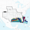
U.S. South - Lakes, Rivers and Coastal Marine Charts​

Garmin Navionics Vision+™ | NVUS006R​


You switch between NJ and FL. You're screwed. You'd need two $250 Vision maps
.Screen Shot 2023-03-16 at 12.00.59 PM.png
 

Hookup1

GreatGrady Captain
Joined
Oct 16, 2007
Messages
2,664
Reaction score
728
Points
113
Age
69
Location
Cape May, NJ
Model
Islander

U.S. South - Lakes, Rivers and Coastal Marine Charts​

Garmin Navionics Vision+™ | NVUS006R​


You switch between NJ and FL. You're screwed. You'd need two $250 Vision maps
.View attachment 28733
Yes I'm screwed. Garmin wants to sell charts! This is all similar to the G2 maps. The only difference the Vision+ offers is shaded relief - which I have for G3 - and I really like.
 

SkunkBoat

Well-Known Member
Joined
Oct 12, 2017
Messages
4,276
Reaction score
1,484
Points
113
Location
Manasquan Inlet NJ
Website
www.youtube.com
Model
Express 265
But the Garmin Navionics + (no vision) is $199 and covers all US Coastal and Lakes and Bahamas

Oh shit... I just clicked on a "Shop Now" link on Garmin and it lets me play with the new map on the web https://maps.garmin.com/en-US/marine/?key=djkqdgzcpfrc

It has full zoom in.....Lake contours AND Coastal out to canyons.


Can't play with Vision though....


oh... Garmin youtube 2022

 
Last edited:

Hookup1

GreatGrady Captain
Joined
Oct 16, 2007
Messages
2,664
Reaction score
728
Points
113
Age
69
Location
Cape May, NJ
Model
Islander
But the Garmin Navionics + (no vision) is $199 and covers all US Coastal and Lakes and Bahamas.
Yep. Just watched the video. The whole thing is a mess right now. The $199 Garmin Navionics+ NSUS001L will give you all the US base maps and Bahamas like the Bluecharts that are pre-loaded. That would give me NJ and FL. I'll probably do this just not sure when.

Also not clear how you replace your Bluecharts with Navionics. On the video you only have one choice of charts for Navigation or Fishing. I would have to assume that installing Navionics replaces Blucharts.

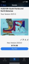
The VUS010R I have for Florida gave me shaded relief for FL. Not clear how this works. It may still work since shaded relief is a additional type of chart. The update is $174.99 for that number. NVUS006R is $250. What I have is good enough for my purposes assuming it still works.

The little bit I have used the Navionics app I do like it. I need to work with it more. Not thrilled with Active Captain. It gets the software upgrade done but it isn't easy to manage waypoints. The Navionics app will remain a product for Garmin - to support other manufacturers mapping needs. Maybe at some point it will come together to be one app for all.

I really like Garmin Homeport for managing waypoint "sets" - load and unload the unit with them. Discontinued - PC version still works. I could hand edit GPX files but that's stupid. I need to find a solution.

Back in the mid 90's I used paper charts, plotted routes through Florida Keys/Bahamas and upload waypoints to a 1st generation Garmin GPS. Soon after I used NavTrek on a laptop or PC and did all my crusing planning on it. The advances in the technology are amazing but the they can't seem to understand how people are using these applications.

A diesel mechanic summed it all up for me one day: "See this? - as he pointed at a fuel filter assembly - This was designed by a couple of college boys on a workbench.".
 

Hookup1

GreatGrady Captain
Joined
Oct 16, 2007
Messages
2,664
Reaction score
728
Points
113
Age
69
Location
Cape May, NJ
Model
Islander
Let's try this...
GarminLogo

SUPPORT CENTER
CHAT
Session started between David and Frank Kacerek

Frank Kacerek: I purchased this unit new November 6, 2022. It should have shipped with Garmin Navionics charts. Can I get my base charts updated without having to buy a subscription for the first year?
SERIAL NUMBER: 5SW000363

David: One moment. Let me look up that serial number

David: That device has G3 with Navionics charts built in. No subscription is required

Frank Kacerek: I have G3 charts - no Navonics charts in the unit.

David: G3 has Navionics. When we went from G2 to G3 we integrated Navionics into our charts.

Frank Kacerek: They don't look like Navionics charts?

David: If you did not receive the most recent chart. We can get that to you as part of our new chart guarantee. Here is a link about that.

David: Garmin Marine New Chart Guarantee

Frank Kacerek: So how do I use this?

Frank Kacerek: I have a BlueChart free update. Is that it?

David: You will download it from Garmin Express. Let me get you the link

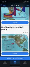
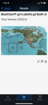
David: It looks like you already have the most recent chart. Your charts show : BlueChart® g3+LakeVü g3 Built-in v2023.0

Frank Kacerek: So when they updated the BlueCharts to Navionics they didn't change the name?

Frank Kacerek: Also these charts show with the Navionics "look" with different color shading then the BluChart?

David: Yes they stopped calling the charts G2 and they named them G3

Frank Kacerek: Once charts are downloaded with Garmin Express to a SD card how do I install them?

David: Just insert the SD card and leave it in your 8610xsv

Frank Kacerek: OK David. I'm downloading now. Thank you for your help.

David: You bet. Have a great weekend!

Frank Kacerek: Thanks

David: The conversation has been ended.

David has exited the session.

The conversation has been ended.


Type Message Here:
 

PNW_Drifter

Well-Known Member
Joined
Oct 20, 2019
Messages
407
Reaction score
158
Points
43
Location
Seattle, Washington USA
Model
Seafarer
Yeah, I agree with Garmin bought Navionics. I wish they had changed their charts to look exactly like Navionics. I’ve been using the app for three years and I love it. I pay 20 bucks for every year. I only use it for bottomfish season, but also armchair, navigating calculating gas burn to different areas. Such a nice interface.

Great post guys I’m on the fence waiting to buy a new chart plotter until I like the look of the new charts. Don’t give me wrong. They are way better than what I have now, but my unit can’t handle anything above G2.
 

Hookup1

GreatGrady Captain
Joined
Oct 16, 2007
Messages
2,664
Reaction score
728
Points
113
Age
69
Location
Cape May, NJ
Model
Islander
OK. So here's what I have been able to figure out.

From Garmin web site product page. New units like the 8612xsv or 1243xsv are shipping with:

PRELOADED MAPPING​

GARMIN NAVIONICS+ INLAND & COASTAL - Experience unparalleled coverage and detail with preloaded BlueChart® g3 coastal charts andLakeVü g3 inland maps featuring integrated Garmin and Navionics® content and Auto Guidance technology1.

OPTIONAL CHARTS AND MAPS​

GARMIN NAVIONICS+™ and GARMIN NAVIONICS VISION+™ - Bring a fresh new look and feel to your chartplotter with optional Garmin Navionics+™ or premium Garmin Navionics Vision+™ cartography featuring integrated coastal/inland content, access to daily updates, Auto Guidance+™technology1 and more.

What the Garmin tech on the Chat site is true - they integrated the Navionics charts with the Bluechart. In order to get the new look and feel of Navionics you would need to buy the new base chart subscription for $200. I'm going to take a look at West Marine and check the units out but I think this is all correct.
 

SkunkBoat

Well-Known Member
Joined
Oct 12, 2017
Messages
4,276
Reaction score
1,484
Points
113
Location
Manasquan Inlet NJ
Website
www.youtube.com
Model
Express 265
So I guess they made G3 the standard instead of "Worldwide Base map"?
Looks to me like its all in flex. The website doesn't seem to know what they sell...
I am sure that they won't keep 2 lines going and updating.

My 1242Plus and Echo74uhd(on my tin boat) have G3. I actually like the look of G3 better than Navionics. I've gotten so used to it. Navionics looks more like a NOAA paper chart.

If I switch it will be for upgrading to Vision+. I just wonder how acurate it is. I think most of it is just using the same old NOAA Bathymetry and making it look 3D.
I know there are areas with HiRes sonar added. There are many in my fishing area.
With the Vision you also get 1 ft depth lines (again, is this from new 1 ft resolution soundings or is it just averaging and smoothing the same old NOAA data)
You get depth coloring.. but the 3d shading kind of makes that moot..
You get Sat images.
You get Photos.
you get underwater 3D "Fisheye" view.
You get NOAA raster charts
I guess I should stop thinking and open my wallet...

As far as Active Captain...I get it... people are doing everything on mobile devices now. Homeport was nice for use oldtimers with Excel...
In the winter, I setup my 1242plus on a battery in my living room and I do all my editing. The touch keyboard makes it as easy as using a computer. You can do the same on and I pad with Active Captain.
In the older mfds you had to arrow left and right and up and down...doing it on a computer was the only way.

I think it can be done in the InReach software on a computer. I have dumped my waypoints there and messed with them but I just find it easier on the MFD now.
 

Recoil Rob

Well-Known Member
Joined
Mar 23, 2019
Messages
277
Reaction score
50
Points
28
Age
68
Location
CT Coast
Model
Sportsman
in 2021 I purchased a 943xsv and paid the extra $250 for the Blue Chart G/3 upgrade.
This year I purchased a second 943xsv to network with the first one and it came with Navionics preloaded.
I was wondering how the 2 would work together when having different chart systems so I called.
I was told that they "should work together" but they weren't sure. They said if there was a problem they would "take care of me"
Not sure what that meant but I'll find out soon when I install the second unit next month....
 

Hookup1

GreatGrady Captain
Joined
Oct 16, 2007
Messages
2,664
Reaction score
728
Points
113
Age
69
Location
Cape May, NJ
Model
Islander
in 2021 I purchased a 943xsv and paid the extra $250 for the Blue Chart G/3 upgrade.
This year I purchased a second 943xsv to network with the first one and it came with Navionics preloaded.
I was wondering how the 2 would work together when having different chart systems so I called.
I was told that they "should work together" but they weren't sure. They said if there was a problem they would "take care of me"
Not sure what that meant but I'll find out soon when I install the second unit next month....
Let's clarify a few things:

"in 2021 I purchased a 943xsv and paid the extra $250 for the Blue Chart G/3 upgrade."
The 943xsv ships standard with BlueChart g3. It is not an upgrade. You probably added a g3 Vision region which gave you a few more features like shaded relief, satellite images, etc.

"This year I purchased a second 943xsv to network with the first one and it came with Navionics preloaded."
As of today on Garmin's web site and in the store state the 943xsv ships standard with Garmin Navionics+ BlueChart g3. Garmin merged all the Navionics chart features with G3 a few years back but did not adopt the Navionics "look". This is a good thing.

"I was wondering how the 2 would work together when having different chart systems so I called."
They are actually not two different chart systems. Both are BlueChart g3. They will work together fine. Once installed you should use ActiveCaptain app to update the software and the BlueChart base map charts to v2023. The new unit should be correct but the old unit is probably v2021.

"I was told that they "should work together" but they weren't sure. They said if there was a problem they would "take care of me""
Both units will work fine but because they may have different versions of BlueChart g3 you may see different detail. I'm sure they can help you fix it. If you goto the system settings>software and look at the last screen you can see the revision of the BlueCharts that are installed.

One last technical problem. The g3 Vision card that you installed is going to be an old revision. I'm not sure how the unit will handle two charts of the same area and which one gets priority - the revision level or the chart type. I'm going to a boating show Sunday. I'll talk to Garmin about this. Probably won't get an answer and have to call Garmin support.

How do I know this?
I have a near identical situation. A 8612xsv purchased in 2021. A 8610xsv purchased in 2012. A VUS010R Florida g3 Vision BlueChart purchased 2021. I updated the BlueChart base maps on both units to v2023 this weekend. The VUS010R is v2021 - it can be upgraded to v2023 but for $180 via ActiveCaptain.
 

Recoil Rob

Well-Known Member
Joined
Mar 23, 2019
Messages
277
Reaction score
50
Points
28
Age
68
Location
CT Coast
Model
Sportsman
Thanks for straightening me out.

You're correct, I bought the Vision upgrade for the first unit.

Interested to hear what you find out.

I've never used Active Captain, perhaps I'll set up the older unit on a battery to update.

What irks me is paying $250 for the card and after a little more than a year it's, while not useless, superseded.

After updating the BlueChart/G3 on the older unit, can the same Navionics in the new unit be installed on the older one if the Vision card is removed?
 

Hookup1

GreatGrady Captain
Joined
Oct 16, 2007
Messages
2,664
Reaction score
728
Points
113
Age
69
Location
Cape May, NJ
Model
Islander
Thanks for straightening me out.

You're correct, I bought the Vision upgrade for the first unit.

Interested to hear what you find out.

I've never used Active Captain, perhaps I'll set up the older unit on a battery to update.

What irks me is paying $250 for the card and after a little more than a year it's, while not useless, superseded.

After updating the BlueChart/G3 on the older unit, can the same Navionics in the new unit be installed on the older one if the Vision card is removed?
I've never used Active Captain, perhaps I'll set up the older unit on a battery to update.
ActiveCaptain is a great tool for updating your chartplotter. It does take some fiddling with to get used to it. Most confusing issue is connection phone to your home wifi and switching to your boats wifi.

What irks me is paying $250 for the card and after a little more than a year it's, while not useless, superseded.
All Garmin charts - pre-installed on the unit or on a SD-card - are 1 year of free updates. Beyond that you have to pay for them. For my offshore fishing and very little travel crusing the updates are not that important. If I were commercial I would be required to keep my charts up to date.

After updating the BlueChart/G3 on the older unit, can the same Navionics in the new unit be installed on the older one if the Vision card is removed?
Yes. You are actually doing a BlueChart g3 update. It can be done with ActiveCaptain or GarminExpress (free PC app).
 

SkunkBoat

Well-Known Member
Joined
Oct 12, 2017
Messages
4,276
Reaction score
1,484
Points
113
Location
Manasquan Inlet NJ
Website
www.youtube.com
Model
Express 265
The OLDER Vision G3 is better than the "non" vision new one. You paid up $250 for it. You also get all the extras unlocked if you use the Active Captain app.
You should be able to update the Vision it to the latest, and I would think you could have updated it thru 2022 for free. The Active Captain App would have downloaded the latest software version for ALL of your registered garmin devices(always free) and any free map updates that were available. You might (probably) still have the 2022 map updates available to you for free. You NEED Active Captain . You need to register all of your garmin devices.You need to learn how to use it or you will have to go on garmin site routinely and find and download updates on Garmin Express to a sd card on a computer. Then its on YOU to find them.

I am pretty certain once you own a map yu can load it on any and all of your registered devices that are compatible.
 

Hookup1

GreatGrady Captain
Joined
Oct 16, 2007
Messages
2,664
Reaction score
728
Points
113
Age
69
Location
Cape May, NJ
Model
Islander
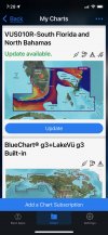
This is ActiveCaptain.

SkunkBoat's suggestion of using Garmin Express is a good one. The maps download and transfer to the SD card much faster with a PC hardwired to your router vs using wifi or cellular on your phone.

Chart>MyCharts
IMG_2821.jpeg IMG_2822.jpeg

If you are running old base map charts you would have the option to update here.
IMG_2823.jpeg IMG_2824.jpeg


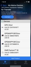
Boat Apps>My Marine Devices. Your GPSMAP unit should be at software revision v30.10
IMG_2825.jpeg


BoatApps>Helm>Pick unit you want to look at.
Options>Settings>System>System Information>Software Information
GPSMAP software revision v30.10 Original base map revision v22.50.
Look at the last screen to see the chart revisions.
IMG_2826.jpeg IMG_2827.jpeg IMG_2828.jpeg
 
Last edited:

SkunkBoat

Well-Known Member
Joined
Oct 12, 2017
Messages
4,276
Reaction score
1,484
Points
113
Location
Manasquan Inlet NJ
Website
www.youtube.com
Model
Express 265
I know we are beating this horse to death but...

West Marine and others are discounting EchoUHD and GPS 94x/124x and GPS86xx that include "G3 lake or G3 Coastal" maps. They only ever discount things when there is a new offering from garmin.
They are clearing inventory.
Sometimes a new offering does not change model#.

The Garmin Navionics+ is not just G3 with a different name. Its navionics with some garmin thrown in. The Garmin Web Site shows EchoUHD2/943/1243/86XX shipping with Garmin Navionic+.
(the 92x/122x/84xx and Echo Ultra102/122 ship with the lesser Worldwide maps and save you ~$100)

Echo UHD is still shipped with G3 (Lake OR Coastal). which tells me its not long for this world, being replaced by UHD2


I don't fault Garmin. Available electronics hardware improves fast and they don't stay stuck on old stuff.
The benefit of using Active Captain is you can download updates as soon as they are released. In fact, it "pushes" them to you. This is to your phone . Then you can installed them into the newer WIFI capable units while you are sipping coffee in your boat.. The updates for all of your garmin networked devices can be done this way.


Also...

Using a Garmin Marine Chart on Multiple Chartplotters​

A marine chart can be used on multiple compatible chartplotters. It is not necessary to purchase individual charts for each device. The chartplotters need to be registered in the same Garmin Express account. Once both are in the same account, a copy of the chart can be downloaded through Garmin Express onto an micro/SD card for the new chartplotter or, if the chartplotter is compatible with ActiveCaptain a copy can be downloaded through the ActiveCaptain application.

Related​

 
Last edited: