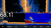
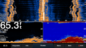
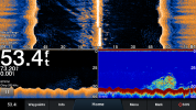
Cool looking new product from Garmin - Garmin GPSMAP 943xsv

SkunkBoat

Well-Known Member
Joined
Oct 12, 2017
Messages
4,215
Reaction score
1,459
Points
113
Location
Manasquan Inlet NJ
Website
www.youtube.com
Model
Express 265
doug228 you're right, it can be run on 455khz. It gives a crisper image. I don't know what I was thinking. Maybe my old Echo94 with CV51 didn't do that.

I was out yesterday and looked for a wreck I had numbers for but have never been on. Without the sidevu it would have taken a lot longer to find it and to mark out the edges.
I took screen shots but I left the sd card in the unit.....get them next time and I'll post

Not sure what problem Hookup is having. For things with straight edges it works great at showing an image. You have to be moving in a straight line for the image to look like something. And it looks more like a picture when the object is to one side. If you are over the object you are better of looking at downvu.

When I've used it on bottom formations like Shrewsbury Rocks, its not as "picturelike" unless there is a straight ledge. Probably because my brain doesn't understand what its seeing. But it still shows that there is a high spot to the left or right, and thats what you use it for.


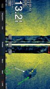
When I look at Hookups image it looks like its working correctly. I flipped the picture to make it easier to understand.
I see a square-ish object in a depression(white arrow) on the starboard side, 40 ft from the surface(on an angle). The bottom is 13 ft straight under the boat(red arrow). I see a bright edge (yellow arrow) that shows that the object is sticking up. I see a shadow (green arrow)of the object.

I don't think its the wreck Hookup is looking for. It seems way too small given the scale of the image. I would guess its a mooring anchor block....but of course...its all in my mind what I see.

sidevu image.png
 

Hookup1

GreatGrady Captain
Joined
Oct 16, 2007
Messages
2,604
Reaction score
714
Points
113
Age
69
Location
Cape May, NJ
Model
Islander
The wreck was from 1715 and has "reached equilibrium". No structure exists and ballast stones have sunk or been covered over. There are 4 or so moorings and yes that is probably what it is. There are 8 or 10 replica canons, a vintage anchor, a memorial plaque and some coral formations.

I would like to see the ones you got when you have time.
 

SkunkBoat

Well-Known Member
Joined
Oct 12, 2017
Messages
4,215
Reaction score
1,459
Points
113
Location
Manasquan Inlet NJ
Website
www.youtube.com
Model
Express 265
Oh, yesterday we were in an area with dozens of Minke and Humpback whales and hundreds of Common Dolphin that were actively feeding on sand eels. The sidevu never showed (what we would consider) whales, even when there were two right next to us. We did see dolphin (arguably). We never read whales on traditional sonar either...unless we are mistaking them for bait. You would think with lungs full of air they would make a solid reading?
 

doug228

Well-Known Member
Joined
Jul 22, 2020
Messages
143
Reaction score
45
Points
28
Age
35
Model
Seafarer
All my research before taught me not to expect soft targets in sidevu or high frequency. SideVu purpose was for structure...so I've read.

I don't pick up much in the water column in 455 downvu. 260 downvu is great and really helps tell what is bottom vs what is fish,bait compared to chirp.

They all help point me in the right direction...not that I can do much fishing here at the moment. Mostly running the prawn traps and touring.
 

Recoil Rob

Well-Known Member
Joined
Mar 23, 2019
Messages
267
Reaction score
49
Points
28
Age
68
Location
CT Coast
Model
Sportsman
Hookup,
Is your 943 flush mounted or on the bail? If it's on the bail would you mind measuring the total height from bottom of bail to top of unit?

I want to put one on my 180 but the sloping windshield may prevent that.


thanks,

Rob
 

Hookup1

GreatGrady Captain
Joined
Oct 16, 2007
Messages
2,604
Reaction score
714
Points
113
Age
69
Location
Cape May, NJ
Model
Islander
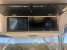
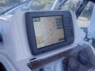
It’s on a custom bracket/mounting tray. I have the bracket though. I’ll check Saturday.

Overhead bx.jpeg 4210a.jpg

Its a tight fit in the box so I built a tray. Two notches in the front to hook into and two screw downs in the back to lock into.
 
Last edited:

SkunkBoat

Well-Known Member
Joined
Oct 12, 2017
Messages
4,215
Reaction score
1,459
Points
113
Location
Manasquan Inlet NJ
Website
www.youtube.com
Model
Express 265
Ok..wish I took more pix but I was going back on drifts in a wind, trying to hold in reverse and catch a fish...

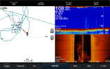
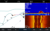
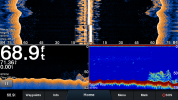
This shot shows the wreck to starboard. I am headed south but there was a bend in my line and you see it as a bend in the wreck. The wreck is not bent. It is long with 2 parallel high spots and a low channel in the center. Probably was some type of barge. Its low, maybe 5-10 ft off bottom.
On the traditional sonar you have no clue that it its there....


3348302862_21OCT 1_1358_00.png

See below;
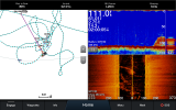
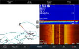
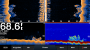
It is covered in bait (sand eels we think) that raises high. you can see a cloud on the sidevu (both sides)that corresponds to the cloud on the Traditional sonar.
You can also see some of the wreck extending out to starboard

There is a lot of junk in the water column when I was backing down to start the drift.
3348302862_21OCT 1_1400_00.png


Notice how far away my waypoint "DAVE MORAN" was for this wreck. That was published numbers. Because I saw the wreck to the southeast when I drove over the numbers, I saved a lot of time not doing circles to the North.

This is a low wreck. High wrecks often look just like a ship if you are running parallel to one of the sides


I have this screen Combo saved as a Favorite named Bottom Combo
 
Last edited:

Hookup1

GreatGrady Captain
Joined
Oct 16, 2007
Messages
2,604
Reaction score
714
Points
113
Age
69
Location
Cape May, NJ
Model
Islander
I would be happy with that! Boat goes in next week. I’ll have a chance to check out. Thanks.
 

SkunkBoat

Well-Known Member
Joined
Oct 12, 2017
Messages
4,215
Reaction score
1,459
Points
113
Location
Manasquan Inlet NJ
Website
www.youtube.com
Model
Express 265
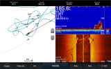
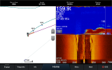
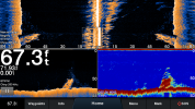
got out to TexasTower#4 wreck looking for tuna. No life...but marked out the wreck using the sidevu. Again, the sidevu helped me find more of the wreck which has fallen down and scattered.

3348302862_08NOV 1_0753_00.png
3348302862_08NOV 1_0808_00.png3348302862_08NOV 1_0809_00.png3348302862_08NOV 1_0748_00.png
 
  • Like
Reactions: JJMag

Hookup1

GreatGrady Captain
Joined
Oct 16, 2007
Messages
2,604
Reaction score
714
Points
113
Age
69
Location
Cape May, NJ
Model
Islander
Thanks SkunkBoat. That looks good. I'm in the water and going to try CM Reef and Site 11 on Monday.
 

Blaugrana

Well-Known Member
Joined
Sep 16, 2019
Messages
703
Reaction score
107
Points
43
Age
40
Location
Bayville, New Jersey
Model
Seafarer
Skunkboat- How come your bottoms look so flat? Is that because of the depth of water you are in?

Granted I am in 10-15ft of water drifting for fluke in the bay, but the chop makes it seem like the bottom is rolling as well.
 

Hookup1

GreatGrady Captain
Joined
Oct 16, 2007
Messages
2,604
Reaction score
714
Points
113
Age
69
Location
Cape May, NJ
Model
Islander
In deeper water a few feet of bottom or structure doesn't show up that well. Need to use the bottom lock and zoom depending on how deep you are..

Bottom lock.png
 

Hookup1

GreatGrady Captain
Joined
Oct 16, 2007
Messages
2,604
Reaction score
714
Points
113
Age
69
Location
Cape May, NJ
Model
Islander
OK. So here are a series of screenshots with 943xsv and GT51M. Combination screen with SideVu, DownVu and traditional sonar. Taken at SW end of Cape May artificial reef. Several large wrecks and some NOAA charted wrecks and obstructions. Overall everything seems to be working but not significantly better than traditional non-chirp. For now it all stays in place.

3358374208_05JUL21_1200_00.png 3358374208_05JUL21_1200_01.png 3358374208_05JUL21_1217_00.png 3358374208_05JUL21_1219_00.png 3358374208_05JUL21_1225_00.png 3358374208_05JUL21_1241_00.png 3358374208_05JUL21_1301_00.png
 

SkunkBoat

Well-Known Member
Joined
Oct 12, 2017
Messages
4,215
Reaction score
1,459
Points
113
Location
Manasquan Inlet NJ
Website
www.youtube.com
Model
Express 265
I think the pix show some benefit to using the Downvu. You can certainly differentiate between wreck and bait where on traditional its just one red blob. I have to admitt I don't use the downvu but maybe I should start playing around with that and bottomlock. Might get a sense of which side of a wreck to fish based on bait/fish readings. You have a different color setting with yellow/blue. I run it just yellow. Too many choices!!! I don't run sidevu 455khz...are you zoomed in?...looks very different than mine. All of your pix are on top of the wreck. For me, the usefulness of the sidevu is when you are looking for the wreck. Once on top it makes no sense.
 

Hookup1

GreatGrady Captain
Joined
Oct 16, 2007
Messages
2,604
Reaction score
714
Points
113
Age
69
Location
Cape May, NJ
Model
Islander
Agreed - I read the numbers and ran them over. It will be helpful when exploring a wreck that you know is nearby but don't have precise numbers. At this point I'll keep all my sonar and transducer options and continue to test. Each one seems to offer something unique. Thanks for all the help!
 
  • Like
Reactions: SkunkBoat

Fishing newbie

New Member
Joined
Jul 26, 2021
Messages
2
Reaction score
0
Points
1
Age
47
Any input from anyone would help. I recently purchased a new boat that came with the Garmin GPSMAP 943xs Plus. We’re encountering a ”freeze” with depth reading. It will freeze and flash. This happens at random depths for a period of 2-5 mins. Almost cost me a lower unit but thankfully I was slowly moving and trimming up before nicking bottom. Thanks for any input.
 

SkunkBoat

Well-Known Member
Joined
Oct 12, 2017
Messages
4,215
Reaction score
1,459
Points
113
Location
Manasquan Inlet NJ
Website
www.youtube.com
Model
Express 265
do you have a transom mount or thru-hull mount transducer? Possibly getting air under transducer and losing returns. Might need angle adjustment if transom mount.
Does it ever happen when not underway?
Possibly bad connection to transducer. Plug on back of 943. If thru-hull, there is another plug near the transducer(somewhere in the bilge)

Look for green corrosion on pins of plug.
 

Fishing newbie

New Member
Joined
Jul 26, 2021
Messages
2
Reaction score
0
Points
1
Age
47
do you have a transom mount or thru-hull mount transducer? Possibly getting air under transducer and losing returns. Might need angle adjustment if transom mount.
Does it ever happen when not underway?
Possibly bad connection to transducer. Plug on back of 943. If thru-hull, there is another plug near the transducer(somewhere in the bilge)

Look for green corrosion on pins of plug.
Thru hull. When I contacted my marina he said this happens with many depth/fish finders as it is getting a hard time reading bottom if it is muck or weedy. Not sure if accurate
 

SkunkBoat

Well-Known Member
Joined
Oct 12, 2017
Messages
4,215
Reaction score
1,459
Points
113
Location
Manasquan Inlet NJ
Website
www.youtube.com
Model
Express 265
I'd find a new marina:rolleyes: You should not lose bottom over mud with that sonar. Thats a BS excuse.
A 943 is brand new.
My 1242xsv with thru-hull GT51m reads bottom on plane at 36 mph in 300 ft. Read bottom tilefishing in 650ft.

Your description sounds like you are losing returns, either from air or bad connection. Hard to say without seeing it first hand.

The only other time Ive seen that is when you are over a giant school of bait and it confuses the top of the bait with the bottom
Maybe very tall weeds in deep water can cause the same effect